

CUTTYHUNK — Lexi Lynch says coming out to Cuttyhunk Island — close to 10 miles off the coast of New Bedford — can feel like stepping back in time.
There are just a few cars on the one square-mile island; most people get around on golf carts. Cell service is spotty. And in the summer, it’s common to see people walking around barefoot and a floating raw bar serving boaters at cocktail hour.
“You go to the beach with a towel and that’s it,” said Lynch, a year-round resident of the island for more than 20 years. “The peace and quiet, the freedom that you have to move around and do what you want, you just can’t find this anywhere else.”
The island supports a full-time population of roughly 10 people — which swells to just under a thousand in the warmer months. And it has provided an “idyllic life” for Lynch and her family. She’s manager of Pete’s Place Rentals, which rents cottages to seasonal visitors on the island.
Yet the times are changing, Lynch says, especially after recent winter storms pushed sand into the island’s federal navigational channel — and nearly cut the ferry off. These same storms caused flooding and property damage in South Coast towns from Wareham to Westport, forcing them to reckon with their future amid climate change, the Light recently reported.
“People like to come here and just kind of detach from the real world,” Lynch said. “And I think we may be losing that.”
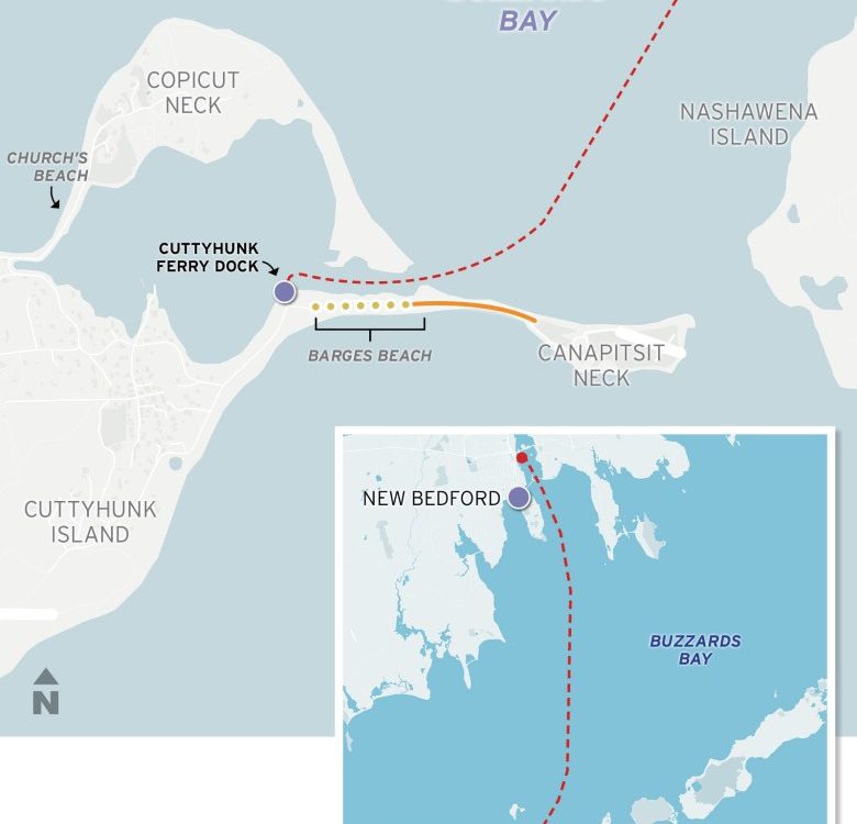
The channel, maintained by the U.S. Army Corps of Engineers, is the only way to get to the island from the mainland. But wave action from storms is significantly eroding Barges Beach, the barrier protecting the 10-foot-deep channel. The waves knock sand from the beach’s dunes into the channel, making it riskier for boats and threatening to cut off larger boat traffic from Cuttyhunk entirely.
“That would be a huge problem,” said Cuttyhunk Ferry Company captain Jono Billings, who has operated the lone scheduled ferry from New Bedford to Cuttyhunk for the past two decades. “It would shut the island down.”
Over the last few years, Billings said, a growing number of strong “no-name” storms blowing from the south — like those in January — have created waves that are eroding more and more of Barges Beach. This is making it difficult for his boat to get into the harbor safely.
“The last storms [in January] have really surprised me, with the amount of erosion,” said Billings. He said two storms knocked four feet of sand off dunes and into the channel.

Billings is concerned that intensifying storms and sea level rise — the mounting effects of climate change in the region — will only increase the amount of sediment pushed into the channel, and the risk of cutting it off.
This same issue that Cuttyhunk is facing is affecting harbors in coastal towns throughout southeast Massachusetts, including Dartmouth, and Hyannis on Cape Cod.
Climate change is expected to produce wetter, longer-lasting, and more intense coastal storms. The Northeast will also likely see more than a foot of sea level rise above 2000 levels by 2050, which will create larger storm surge waves.
“I think it’s something to get used to,” Billings said. “I think we’re in for more windy times.”
Billings’ boat brings over the vast majority of the island’s visitors, mail, food, and business supplies from New Bedford. It’s Cuttyhunk’s only reliable access to the mainland. The island has no year-round doctors, restaurants, or grocery stores.
“If we didn’t have the ferry, we’d have to think hard about our future on the island,” said town clerk and year-round resident Lisa Wright.

The island also relies on fuel and trash barges that pass through the channel to deliver services. And a closed channel would cut off Cuttyhunk from hundreds of thousands of dollars in revenue from visiting boaters and seasonal residents — keys to the local economy.
“If the island shuts down, we’d lose everything,” Lynch said. She and her husband also operate the Cuttyhunk Cafe and Cuttyhunk Fuel and Supply — a dockside gas station and convenience store.
Officials on Gosnold — the smallest town in Massachusetts, with an official population of roughly 70, comprising Cuttyhunk and the rest of the Elizabeth islands chain — say recent winter storms have made it clear they can not put off a solution for Cuttyhunk any longer.
They are working with the Corps and Buzzards Bay Coalition — which now owns Barges Beach — to develop a long-term plan for securing the channel. The town and the Corps hope to double the length of a quarter-mile stone dike along the beach — a longstanding idea that has run into environmental concerns in the past.
The Corps plan to conduct a drone survey of the dike later this spring that will inform a report to the town on options to stabilize the beach, said Gosnold Selectboard Chair Gail Blout. The parties hope to have a plan within the next few months.
Billings said the island was lucky that a Corps dredge was already on site for scheduled work when the second storm hit in January. Otherwise, the channel would have been blocked off.
“We’re in that crisis mode, because I don’t know that you’ll get that lucky next time,” said Mark Rasmussen, president of Buzzards Bay Coalition.
Shaped by storms
Gosnold’s conservation commission chair, David Warr, said Cuttyhunk’s navigational channel was last blocked by sediment in the late 1940s. The town shut down the harbor, and the Cuttyhunk ferry had to drop anchor in Buzzards Bay.
“Somebody from the island would come out to bring us in,” he said. “They took these old bass boats out to get us.”
The problems of storms and sediment blocking the navigational channel are not new to Cuttyhunk’s residents. The channel itself was likely created by the Great Colonial Hurricane in 1635, which may have split what was Elizabeth’s Isle into Nashawena and Cuttyhunk Islands.
After tourism to the island spiked in the 19th century, the Corps and Commonwealth built out the channel in 1907. Yet repeated storms and hurricanes caused sediment from Canapitsit Neck — the sandy spit that forms the channel’s southern shore — to fall into the navigational channel. So the Corps had to repeatedly re-dredge it.
The Corps started work to stabilize the western part of Canapitsit Neck in 1949, sinking 14 wooden barges along the beach’s Vineyard Sound side to create Barges Beach. Yet Hurricane Carol damaged the project in 1954. Corps engineers started work on a stone dike to further stabilize the channel in 1963. Yet they only built a quarter-mile of it — half the proposed length — east of Barges Beach before Congress cut off funding in 1965.
While the eastern end of Canapitsit Neck, along the dike, has remained stable, the sunken barges underpinning Barges Beach on its western end have eroded. This has been contributing to breaches and silting in the channel. And stronger storms and more frequent breaches have necessitated that the Corps dredge more often, and more urgently.
From 1938 to 1990, the channel had to be dredged 11 times for silting issues, or about once every five years. From 1990 to 2024, the channel was dredged eight times, about once every four years. It was dredged twice in the past five years, including in February after December and January storms battered the region.
Recent dredgings have removed more sediment from the channel than those in the past, a consequence of stronger “no-name” storms, Blout said. The most recent dredging in February removed more than 15,000 cubic yards — which presented a crisis situation.
Getting the Corps out to Cuttyhunk isn’t easy, Blout said. The number of dredging projects the Corps has to do on the East Coast is growing with climate change. And getting federal funding allocated to a dredging project can take years, Blout said.
Billings said that while he appreciates the Corps’ dredging work, silting in the unprotected section of the channel “starts up again as soon as they leave.”

Losing access to Cuttyhunk’s harbor would pose a grave financial risk to Gosnold. Revenue from the wharf and marina generated more than a third of the town’s $1.5 million annual operating budget. Seasonal travel is the island’s major economic driver; Billings said 20,000 people take the ferry per year.
This accounts for more than 60% of the revenue for Pete’s Place, Lynch said. She added that 75% of the revenue from Cuttyhunk Cafe is from visiting boaters and day-trippers.
The “resourceful” year-round residents of Cuttyhunk would find a way to survive without the channel, Lynch said; “we always do.” But, she added, “If we don’t have the boaters coming in the summer to buy ice cream and cookies, then we got nothing.”
Rasmussen said Barges Beach is among the most popular beaches on Buzzards Bay, and also among the most vulnerable to storm erosion and sea level rise. Cuttyhunk’s harbor is also a federally-recognized safe harbor for vessels to take shelter in during storms. Rasmussen said Buzzards Bay Coalition wants to see the channel maintained long term.
“There are other parts of the bay landscape where we will be retreating from in years to come,” Rasmussen said. “But I don’t think closing a harbor of that significance would be one of those.”
Gosnold leadership has been working with the Woods Hole Group — a local environmental engineering firm — to evaluate long-term options for stabilizing the beach, Blout said. She said the Corps and the town agree that extending the dike onto Barges Beach would be the best way to stabilize the beach.
“Where the stone dike is, the beach has remained intact,” she said. “For more than 60 years, the dike has protected that portion of the beach. It will protect the other part of the beach.”
Other options include building a sand-cobble berm, or a traditional beach nourishment program.
Blout said that a sand-cobble dune restoration would likely cost roughly double Cuttyhunk’s operating budget and not hold up in a major hurricane. She added that a beach nourishment program — suggested by state environmental agencies as another solution — would likely need to be replaced twice per decade, and put even more sand in the channel during storms.

Armoring beach ruffles feathers
The Corps and Gosnold leadership have been “adamant” in recent decades that extending the dike is the solution for the channel. Yet state environmental agencies have resisted, saying it’s — quite literally — for the birds.
Migratory piping plovers and least terns nest on the low dunes of Barges Beach in the spring and summer. Piping plovers are listed as threatened on the national and Massachusetts endangered species lists, and their nesting areas are protected from human disturbance. Least terns, listed as a species of “special concern” to the state, also have their nesting areas protected under the Massachusetts Endangered Species Act.
In 2022, 32 nesting least tern pairs were spotted on Barges Beach, along with five pairs of nesting plovers.
In 2005, the Corps submitted an application to complete the second half of the stone dike planned in the 1960’s: another 1,300 feet of it, 5 feet wide, on Barges Beach.
Yet the state halted the process that year over environmental concerns. State officials said then that extending the dike would not be permissible under the Massachusetts Wetlands Protection Act, because constructing a permanent structure on a barrier beach could lead to its decline, which would have “adverse impacts” on the nesting plovers and terns.
The state proposed that the Corps build a cobble berm, or conduct a regular beach nourishment plan.
After receiving this pushback, Blout said, Gosnold leadership and the Corps decided to continue regular dredging. Yet Gosnold has learned that the Corps lacks the authority to put the dredged material back on Barges Beach, as state agencies suggested back then.
Instead, the Corps has been moving the dredged material to Church’s Beach, on the other side of the island. That’s “counterproductive” to the health of Barges Beach, said Rasmussen of Buzzards Bay Coalition, since removing sand weakens the barrier’s structural integrity and makes the channel more vulnerable.
Rasmussen argued that strict Massachusetts laws protecting the existing state of barrier beaches and threatened species are well-intentioned, but the core principle underlying them is “outdated” amid the mounting effects of climate change.
A state environmental spokesperson did not take a position on extending the dike, noting that there is no current proposal for the state to consider. “The state has been working with Gosnold on beach nourishment options,” the spokesperson said, “and will continue to support local efforts to address climate change impacts in a sustainable manner.”
There are ways to build a permanent structure on the barrier beach while maintaining habitat for these threatened bird species, Warr said. Yet it will require Cuttyhunk residents to comply with Buzzards Bay Coalition signage limiting where people should walk during nesting season, as well as other rules protecting birds on the island.
“It’s not that we want the birds on Barges to go away,” Blout said. “We’re just trying to come up with a solution so that both parties, the birds and humans, can live together.”
Completing the stone dike or a sand-cobble berm will cost more than $3 million, Blout said. The town would likely need to seek federal funding for any sort of structure on the beach.
Blout added that while Cuttyhunk may be a small little dot on the map, the community “is like a small family,” and Gosnold leadership will work at the issue until its future is secured.
“I think you just have to keep at it, and not give in,” she said.
Email climate and environment reporter Adam Goldstein at [email protected].
MORE BY ADAM GOLDSTEIN
The post Climate concerns hit Cuttyhunk appeared first on The New Bedford Light.